


Across the US, city governments are planting trees in an effort to clean up air pollution, beat the heat, and combat climate change. But when it comes to taking soot out of urban airways, the species of tree and where it is planted can have a big impact on how well it can do the job.
These are some of the conclusions of a long-term collaboration between Cary Institute ecosystem scientist Kathleen Weathers and Alexandra Ponette-González, professor at the University of Utah and curator of urban ecology at the Natural History Museum of Utah.
Black carbon refers to the dark, sooty particles that waft out of power plant smokestacks, vehicle tailpipes, and, increasingly, wildfires. For nearly a decade, Weathers and Ponette-González have been trying to ascertain where all that black carbon goes.
As Weathers puts it: “What goes up, must come down — but where?”
Understanding black carbon’s movement through the urban environment is important because it has been linked to a variety of health problems, including lung disease, cardiovascular issues, cancer, and birth defects. Black carbon is one component of fine particulate matter — also called PM2.5 — the leading environmental cause of poor health and premature death. It also contributes to climate change.
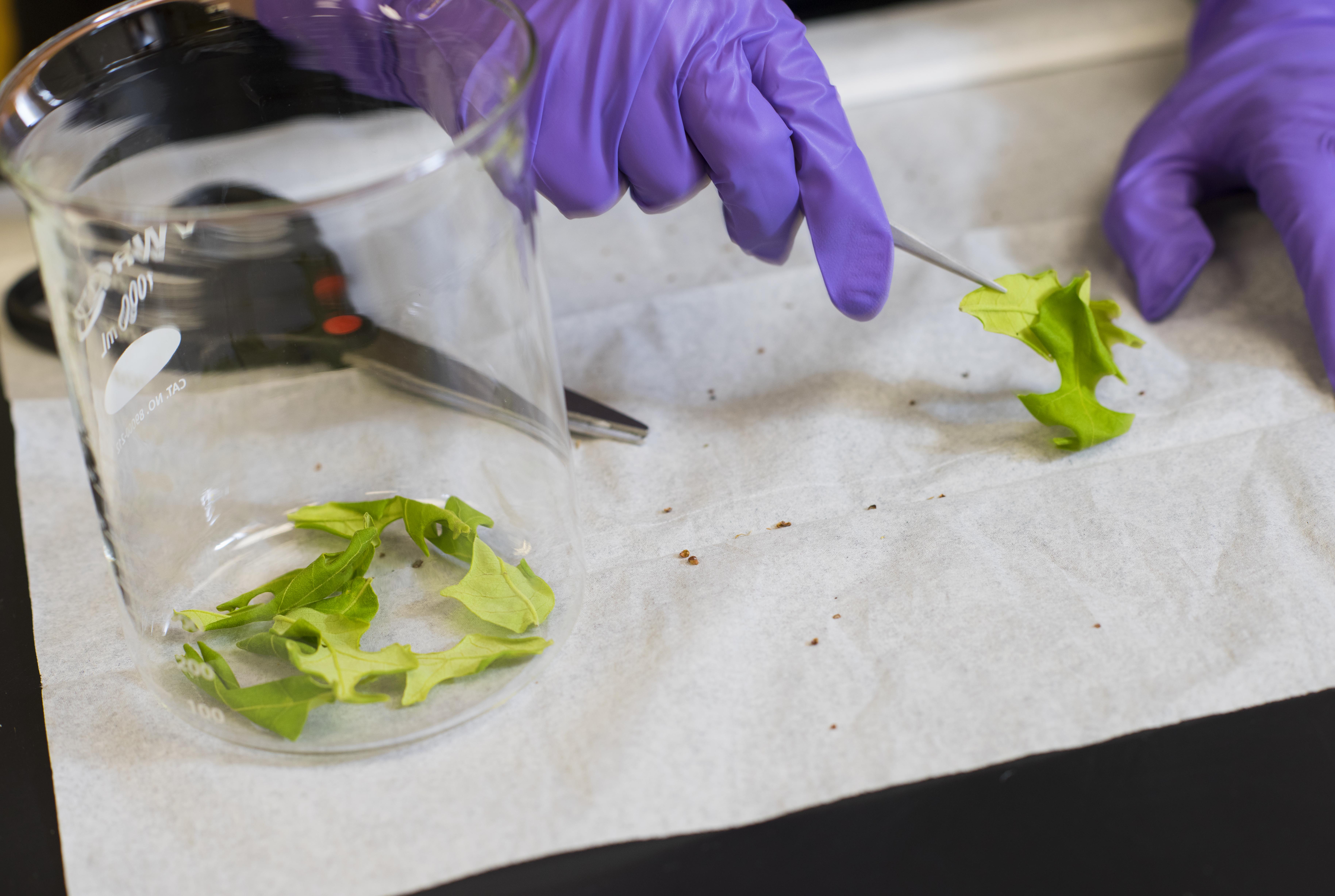
Ponette-González and Weathers led a team that first quantified how much black carbon urban trees can capture on their leaves from the air. These measurements involved picking the leaves off of trees in Denton, Texas, then washing them with water and chloroform to collect the particles from their surfaces. “After that,” says Ponette-González, “it's like filtering your coffee — you just separate the grains from the liquid with a filter, and you use an instrument to measure what's on that filter.”
Their findings were surprising. “Over the course of a year, leaves collect about four times more black carbon than you measure in rainwater, which is the other main way black carbon leaves the atmosphere,” says Ponette-González. “We found that the amount of black carbon that was being captured by the leaves was equivalent to about a third of the local population's vehicle emissions of black carbon.”
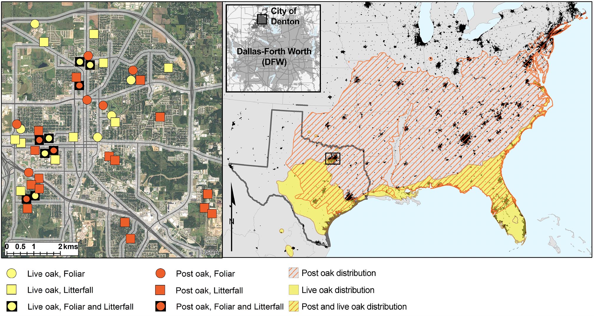
She and Weathers have also been working to better understand which factors contribute to black carbon deposition on leaves. Tree species matter, for example. In Denton, they found that the leaves of post oak trees (Quercus stellata) accumulated almost twice as much black carbon than the leaves of live oak trees (Quercus virginiana).
Black carbon deposition also varies block to block. In a 2023 study, Weathers and Ponette-González analyzed 226 features in the Denton environment to see which were associated with higher levels of black carbon removal by trees. They found that the leaves that captured the highest amounts of black carbon were most likely to be located near stop-and-go traffic such as bus stops, four-way stops, and intersections with traffic lights. Road density and traffic levels were also important.

The results are intended to guide the city’s greening efforts by identifying priority areas where planting trees could remove the most black carbon, resulting in health and climate benefits. They also mapped out 1,659 hectares of land in Denton that, if planted with post oaks, could potentially remove more than 10,000 pounds of black carbon per year.
The team didn’t stop at leaves; they also wanted to find out where the black carbon goes from there. In a 2022 study, they found that 40% of the black carbon deposited on trees falls down to the soil — via wind, rain, or leaffall — where it can have beneficial properties such as absorbing contaminants and helping to filter water, much like the charcoal filter in a fish tank. It can persist in the soil for hundreds or thousands of years.
Outreach efforts led by Ponette-González have helped to bring these findings to Denton residents, neighborhood associations, and the city council, in hopes of helping the scientific findings get translated into real-life impacts.
“They're still citing our research in city council meetings,” says Ponette-González, although she’s uncertain whether it’s made a major dent in urban planning strategy yet. The population of Denton is growing rapidly, and trees are being lost faster than they’re being planted, she says, to make way for development.
But the findings’ implications extend far beyond Denton. Trees in cities across the U.S. likely have similar potential to capture black carbon and funnel it from the air to the soil.
Urban foresters balance many factors in deciding which trees to plant and where. These decisions depend in part on where people want trees, and what purpose the trees will serve — such as cooling the neighborhood, absorbing flood waters, and supporting biodiversity or mental health. Weathers and Ponette-González hope their work offers one more layer of information that planners can use to fine-tune where they plant trees.
Next steps
The seeds of this fruitful collaboration were originally planted back in 2002, when Ponette-González was Weathers’ graduate student and both scientists were studying fog. Black carbon may seem like a major shift from fog, but both topics hearken back to the theme of ‘what goes up into the atmosphere must come down — but where?’
Whereas some contents of the atmosphere fall vertically out as rain or snow, fog and the transfer of black carbon onto tree leaves both involve processes of horizontal deposition. “When particles and droplets move horizontally, the landscape onto which they bump into really matters,” says Weathers. “There is a lot of spatial variability in surfaces — textures, if you will, such as leaf surfaces and steep slopes — and we need to understand how those textures control where droplets and particles land, because that's where we are likely to find effects."
Now, Weathers and Ponette-González are building from what they have learned from fog and black carbon to investigate a burgeoning new problem: the horizontal movement of wildfire smoke and ash across vast areas. Their paper published in April reveals a way to leverage satellite data to predict where these harmful air pollutants end up, in an effort to avoid negative impacts on human health, ecosystems, and the economy.
“This is our first product from this bigger idea of understanding fire and ash deposition — the first of many, I’m sure," says Ponette-González.
Weathers adds, “What’s going up today is increasingly the result of massive wildfires. We need to know where it is coming down and what it means for the receiving ecosystems.”


