Contributors: Vicky Kelly – Cary Institute of Ecosystem Studies; Andreas Colliander – Jet Propulsion Laboratory, California Institute of Technology; Michael Cosh – USDA ARS Hydrology and Remote Sensing Laboratory
Soils all over the world contain different amounts of water, and these levels are constantly changing. This water provides critical support for life on Earth. Soil moisture regulates plant growth, affecting wildlife and ecosystems. It also controls water and heat exchange between the Earth and atmosphere – processes that determine weather patterns.
Measuring soil moisture with ground sensors is a time- and resource-intensive process requiring many hands. Plus, soil moisture is highly variable across the landscape. For these reasons, we cannot rely on ground sensors to monitor soil moisture on a global scale. Instead, scientists are using satellites.
NASA’s SMAP (Soil Moisture Active Passive) satellite was launched on January 31, 2015. Its job is to monitor the water content in soils around the globe. A project using the SMAP satellite, called ‘SMAPVEX19-21’, found that the satellite’s sensors are able to ‘look’ through leaves to detect soil moisture in temperate forests. The study, coauthored by Cary Institute’s Vicky Kelly with a team of collaborators, was recently published in the journal Geophysical Research Letters.
Soil moisture data has many applications
Tracking changes in soil moisture, and observing patterns, can improve weather forecasting and hone crop yield and seasonal water availability projections. Soil moisture can foreshadow natural disasters like floods, droughts, wildfires, and landslides – helping emergency planners prepare for extreme conditions. It can also help policymakers anticipate changes in water security and food production. Climate scientists predicting future conditions on Earth, hydrologists measuring waterflow in river basins, and disease control and prevention managers can all put soil moisture data to use.
Coauthors Vicky Kelly, Andreas Colliander, and Michael Cosh answer questions about the SMAPVEX19-21 project
What does the SMAP (Soil Moisture Active Passive) satellite do?
Since its launch in 2015, SMAP’s sensors have been looking down into the Earth’s top 5cm of soil and taking measurements of moisture, scanning the surface of the entire globe once every three days. The sensors also record data on whether soil is frozen or thawed, which is an important indicator for growing season and carbon cycling.
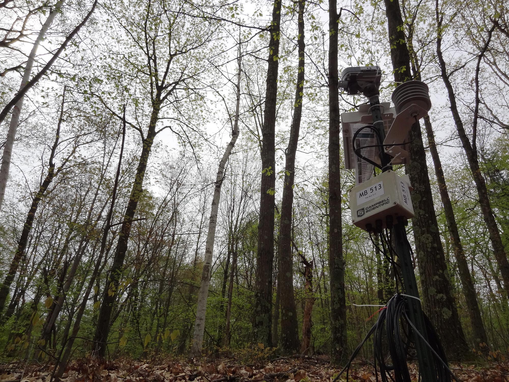
Sensors housed in stations on the ground take measurements of soil moisture and environmental conditions. These measurements are used to calibrate satellite data. Photo by Michael Cosh.
How does soil moisture influence ecosystem health? Why is it important to measure?
There’s a lot of water trapped in soil and it plays an important role in crop and forest production, droughts, floods, weather, and temperature regulation. For example, you may have noticed that a heavy rain after a prolonged drought doesn’t change the water level in a stream. But a light rain after a long wet period will cause a flood. That happens because the soil is saturated with moisture and can’t absorb any more water. So the water runs directly into streams and rivers. Knowing how much water is in soil is critical to knowing the potential for floods and droughts, along with agricultural productivity and weather forecasting.
The SMAP satellite collects data feeding many projects. What was your focus in this study?
Intensive ground truthing is needed to generate accurate satellite measurements of soil moisture. This is where our project, the SMAP Validation Experiment 2019-2021 – aka SMAPVEX19-21 – comes into play.
The goal of this project is to calibrate and validate SMAP satellite data – specifically over forested terrain. Originally, the SMAP mission aimed to collect soil moisture data over landscapes dominated by grasslands, crops, and other low-growing vegetation. However, much of the Earth’s surface is forested, and it’s important to include these areas in soil moisture monitoring. With this study, we wanted to determine whether SMAP sensors could ‘see’ through leaves to retrieve accurate soil moisture data in forests. Our findings – a combination of data derived from the satellite and ground sensors – show that it can.
In terms of the project’s geography, we are monitoring soil moisture across two swaths of land the size of SMAP’s 20 x 20 mile ‘footprint’ – the area that it ‘sees’ looking down at Earth from space. These two focal tracts include 23 ground stations scattered around Harvard Forest in Petersham, Massachusetts, and 25 stations around Cary Institute of Ecosystem Studies in Millbrook, New York. Instruments at these ground stations constantly take measurements of soil moisture and temperature, as well as air temperature and leaf condition of surrounding trees. Meanwhile, up in space, the SMAP satellite is taking measurements at a low microwave frequency.
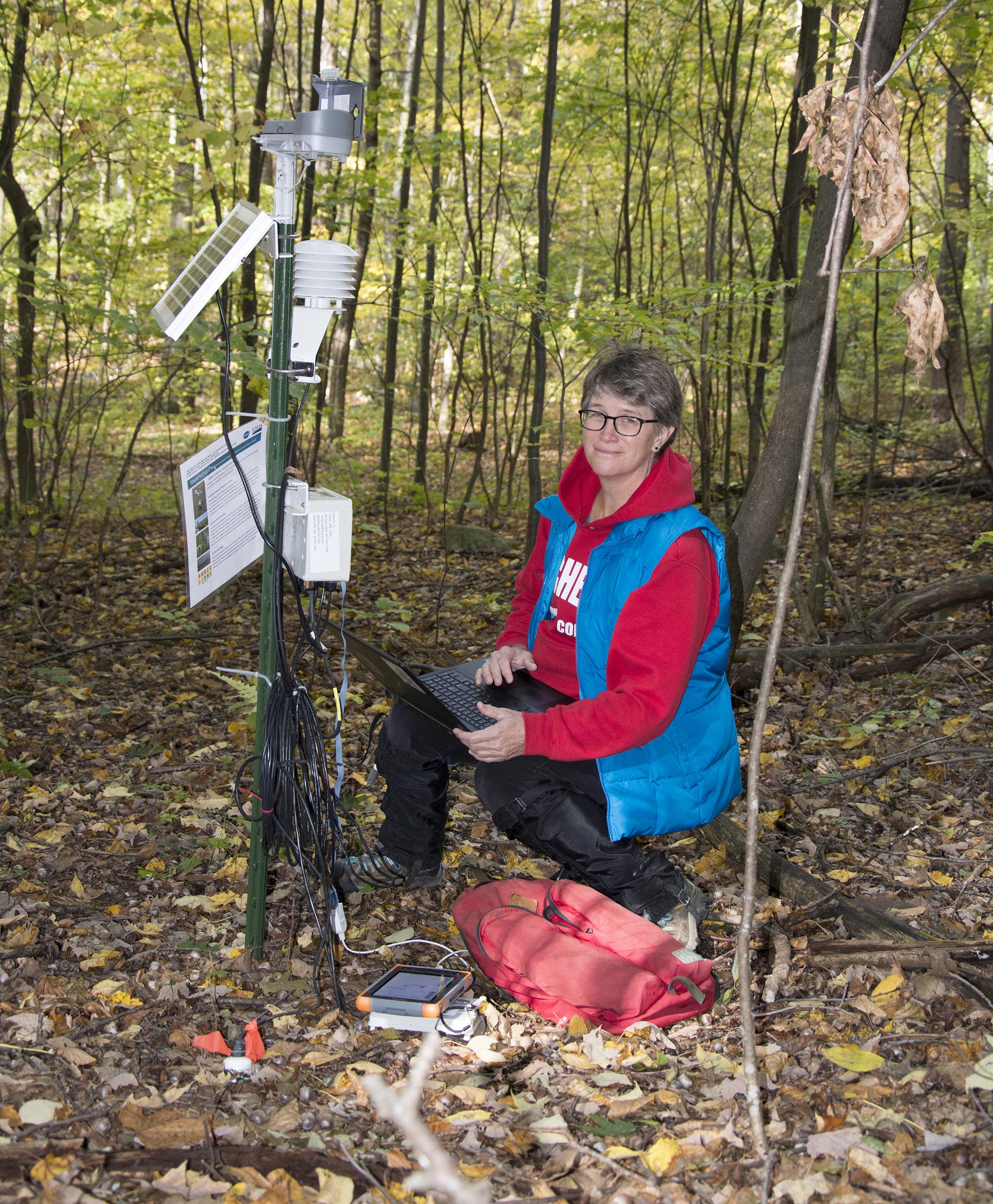
Cary Environmental Monitoring Program Manager Vicky Kelly collects data from a ground sensor in Dutchess County, New York. Photo by Pam Freeman.
What information does the SMAP satellite detect, and how does that data translate to measurements of soil moisture?
The Earth is constantly emitting microwaves. This is the same frequency used to heat food in your kitchen. Microwaves are also detected by weather satellites; this data allows meteorologists to produce colorful weather maps to forecast precipitation and track storms.
Water presence affects microwaves. The SMAP satellite is outfitted with a microwave-detecting instrument called an L-Band radiometer that ‘sees’ into soils. Variations in microwaves emitted from the soil correspond with changes in soil water moisture.
To translate satellite readings to soil moisture, we compare SMAP’s microwave data with moisture readings taken in the soil, and in the vegetation growing in that soil, at the time of SMAP’s flyover. This is how we calibrate the satellite data to learn what’s happening in areas that aren’t being directly monitored by our ground stations.
This process must be repeated for different locations, vegetation types, and seasons. Our goal is to develop universal equations that will allow us to extrapolate SMAP data to monitor soil moisture globally.
What sorts of on-the-ground management activities can SMAP-derived soil data improve or support?
The SMAP satellite will provide important data to drought and flood monitors. It will also inform farmers and the agencies that support agriculture so that critical water resources are used efficiently and effectively.
During the intensive monitoring period planned for summer-autumn 2021, soil moisture measurements will be taken via aircraft, as well as satellite and ground sensors. Photo by Sidharth Misra.
What are the project's next steps?
In addition to continuing data collection with the ground sensors, we are planning two intensive observation periods in July and October 2021. Teams of scientists and graduate students will collect ground measurements, providing firsthand data on conditions in the New York and Massachusetts study sites. These two periods will coincide with flyovers of both the SMAP satellite and an intensively instrumented aircraft.
We are looking for volunteers to collect data during these two observation periods. Observers will travel to specific sites early in the morning when the satellite passes over. They will collect samples of soil and take many measurements of soil moisture with handheld instruments. In the afternoons, we’ll take moisture measurements of trees. Fingers crossed that we’re able to travel in summer-autumn 2021. If not, our ground sensors will still have collected a trove of valuable information.
Citation
Colliander, A., Cosh, M. H., Kelly, V. R., Kraatz, S., Bourgeau‐Chavez, L., Siqueira, P., et al. (2020). SMAP detects soil moisture under temperate forest canopies. Geophysical Research Letters, 47, e2020GL089697. https://doi.org/10.1029/2020GL089697
Acknowledgements
This work was made possible with support from the National Aeronautics and Space Administration. A contribution to this work was made at the Jet Propulsion Laboratory, California Institute of Technology, under a contract with the National Aeronautics and Space Administration. We would like to thank Dr. Charles D. Canham for processing the U.S. Forest Service Forest Inventory and Analysis data.